At 8:32AM PST, May 18 1980, on a Sunday morning, Mount St. Helens erupted in one of the most studied eruptions ever.
A 5.1 Richter scale earthquake caused the northern face of the mountain to collapse. It dropped over one half cubic mile of debris into the valley below, the largest avalanche ever recorded.
The avalanche released an enormous blast wave of hot gas and rock particle debris, with temperatures as high as 660 degrees and a speed of at least 300 miles per hour. The blast was phreatic, the result of super heated water trapped within the mountain. The actual blast began about 20 seconds after the avalanche began, and at the speed of something exploding, rapidly overtook the avalanche. It blew 6.6 billion tons of material with the force of 20,000 Hiroshima-class atomic bombs, 24 megatons of thermal energy. Its devastation reached out almost 16 miles from the volcano’s center
The blast killed campers 14 miles from the mountain. All told, the eruption killed 57 people.
Almost 230 square miles of forest was blown down.
A cloud of volcanic ash rose 15 miles into the air. It spread across the US in 3 days, and circled the earth in 15 days. There were 22,000 square miles of land with varying amounts of ash deposited on them.
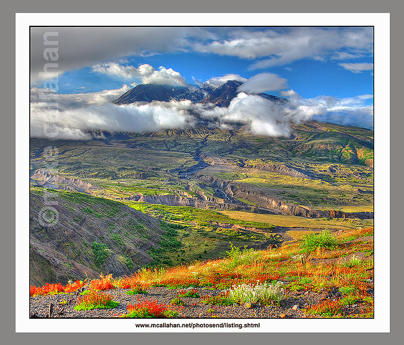
In August of 2007 I visited Mount St. Helens National Volcanic Monument. I was happy to see the progress that Mother Nature is making in remaking the tortured landscape around the volcano.
But the scars are still visible on the land.
The 110,000 acre National Volcanic Monument was created in 1982 by President Ronald Reagan and Congress. It is jointly a research, recreational, and educational project. Much of the site is within a boundary line which only authorized personnel may cross. This is to minimize the effect of man on the area, that it may be left to respond to the disturbance naturally, and provide a study of the process. There is climbing allowed along a specified route to the crater rim, but entry into the crater is strictly prohibited.
Johnston Ridge Observatory Complex building has a number of educational exhibits, and even an IMAX movie presentation. There is also a monument to those who lost their lives in the eruption. The stories of what happened to the wildlife and plants in the blast zone were fascinating.
I was struck by the color in the landscape, as Mother Nature works to restore it to a more gentle state. The pronounced scarring on the land offered a stern counterpoint to this process, and a reminder that it will most likely all happen again at some time in the future.
For an interesting statistical summary of the 1980 Mount St. Helens eruption, check out this website: www.mtsthelens.com