Dark red door on Memorial Day holiday.
Infrared Digital Photography
Image
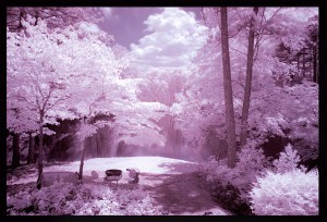
I recently bought a IR760 filter to use on my Nikon D200 camera, as I’ve developed an interest in taking infrared digital photographs. This filter mostly allows only infrared wave length light to pass thru it and be recorded by the camera’s sensor.
With some trial and error, and long exposure times, I managed to get this shot of the lake in full 1PM afternoon sunlight.
Most digital cameras have a built-in filtering function to block infrared wave length light. That’s because for ‘normal’ light images, infrared light will damage the quality of the photograph. So with an un-modified digital camera, you are somewhat fighting one thing to achieve another. You are trying to collect and use infrared wave length light, while your camera is trying to block those same wave lengths of light.
Unfortunately for my infrared photography, the Nikon D200 is known to have a very effective block of those ‘un-wanted’ infrared light waves. This results in very little infrared getting to the camera sensor, and correspondingly long exposure times. Not ideal.
So I’m thinking I will eventually get another camera body – modified especially for infrared ability. The modification involves removing the built-in filtering block on infrared light.
More equipment to carry. More expense.
It never ends, does it.
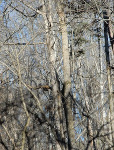
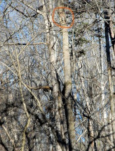
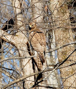
Hiding in plain sight
BIG Blue
Image
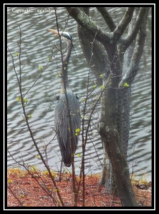
We have a Great Blue Heron who visits us frequently. Big Blue struts slowly along the edge of the water, spearing anything he can with that sharp beak of his. Mostly he just takes small minnow sized prey. But I have seen him get a small fish probably about 7 to 8 inches long, and then really struggle to control it and swallow it afterward.
He is very skittish. A human coming outdoors anywhere around the lake will put him up into the air. When truely startled or challenged by another bird, he is the loudest animal on the lake. The noise he makes I can only compare to the sound of someone banging bamboo sticks together very rapidly.
Because of his timidity with respect to humans, I had to take this shot from inside the house thru window glass and screen. Thus it’s photographically not really up to the quality I try for – pale, washed out, and slightly soft (diffusion effect of the screen I suspect). But I couldn’t just not show him to you. So I will apologize for the quality of the photo, and hope maybe someday I can catch a shot of him from outside the house.
They’re back…
In my last missive I mentioned the frogs on the lake. Every year they make their presence known again earlier, and in colder weather, than we ever would have supposed.
True to form, on February 24th I started hearing the small noises that the baby frogs make as they begin to sound off around the lake. Also true to form, it was 35 degrees the next two days, and I could not believe those little frogs were surviving in that cold. But survive they do. Even thrive. Every year.
By the middle of the summer, they will be so loud that they are the dominant sound out here at night. Even with the air conditioning on, and everything closed up tight, you can still hear them from inside the house.
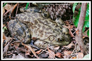
The picture shows a fully grown adult frog in our garden. It was taken last fall when he was sluggish and allowed me to get close to him. He is about 6 inches long. For scale, that is a full size pine cone off to his left.
As I said before, you would certainly never know frogs are in any kind of environmental trouble if you were listening at this lake in the summer. I only wish they were doing as well everywhere else.
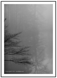
Foggy Winter Morning – Honey Lake
This winter morning the water is so flat and reflective that it’s hard to tell where the shoreline stops and the lake water begins. There are no Canadian Geese (Birdicus Annoyicus) honking around in the water. There are no foxes trotting around the lake. I don’t see the doe with 2 fawns standing by the shore either. No hawks are flying overhead. Nary a beaver nor an otter grace the lake today. It’s just dead quiet out here, with the silvery storm light refracting in the fog to take all the harshness out of the light.
I don’t hear any bullfrog sounds. During the spring and summer, they call to each other back and forth across the lake, I suppose with challenges to fight, and maybe invitations to hookup. And you’d certainly never know frogs are in any kind of environmental trouble if you were listening at this lake in the summer. But soon we will hear their calls again while it is still yet freezing weather here in Georgia. Every year we are always surprised at how early the frogs appear again. How do they stand that freezing cold when they are still so small?
Then there is the otter and beaver(s) which visit us. I’ve been wondering: How does an otter, and a pair of beaver, make their way safely to this lake in the middle of our residential area? The two small feeder streams flowing into this lake go underground 1000 feet or so north by east from here. The animals have to come from downstream of us. The dam spillway outflow stream is very small, at the most 2 to 3 feet across and less than a foot deep. The nearest lake south that the outflow stream flows into is about 1/2 mile away. So how can they suddenly appear here on this lake with fox, dogs, and people surrounding them while getting here?
And speaking of things we don’t know: Is Honey Lake really even the name of this lake? It appears on many maps that I’ve seen, but is never named. The Honey Lake name comes from long time residents of the neighborhood, who in turn have had that information handed down to them from other more elderly local area residents. Allegedly, 55 or more years ago, this was a stocked fish camp lake that folks came up to in order to get away from the city. With the size of the fish pulled out of this lake, I believe that is true. And I guess Honey Lake sounds as good as any other name to me.
That’s enough wondering for now. Back to enjoying the view, and the peace and quiet.
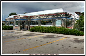
Penny’s Diner in Morrill, Nebraska, USA
There I was, ‘heads down’ driving from Glacier National Park in Montana thru Morrill Nebraska to points east. In a blink I drove right past this flashy, luminescent, silvery, art-deco looking diner straight out of Americana.
Now, the landscape and scenery had been pretty flat and routine for what seemed a long time along that route, so the diner really jumped out at me.
Of course I had to turn around and go back to take a few photographs.
Thoughts of the waitress serving me a piece of hot, home made apple pie ran through my mind. With a slice of cheese on it, and a scoop or 2 of vanilla ice cream, I was big time waxing nostalgic for the good old days. But, being in make-time travel mode, I thought my thoughts, shot my shots, and jumped right back on the road again.
Yeah, all right, it did take a little bit of the romanticism out of it when I later googled Penny’s Diner and found out that it is a commercial franchise chain and not a small entrepreneurial throwback.
But hey! I wish now that I HAD gone in for that piece of apple pie….
Patricks Point State Park, just north of Tridad, California, USA
The next time you are in the area of the small town of Trinidad in northern California (which is where I would live if I was living in California) stop in and see Patricks Point State Park. It’s just a few miles north on Highway 101 from Trinidad, and well worth the drive. With the fog rolling in off the ocean and into the forest, hearing Sea Lions and Seals barking from the rocks jutting out of the water, it’s quite an atmosphere.
With 632 acres in the park, activities include camping, hiking, beach combing, nature sight seeing, and more. Forest and meadowland stretch down to ocean beach front, with spruce, hemlock, pine, fir and red alder growing wild. The ocean frontage ranges from dramatic large rocky promitories and sheer cliffs, to wide sandy white ocean beach. Deer, Sea Lions and Seals are commonly seen from within the park.
With fog coming in at some time almost every day, the vegetation is lush and green. Ferns growing wild and luxuriantly. Coming from the parched drough stricken east, that really stuck in my mind.
And, if you wish for striking photography, nothing sets it up like the wild storm lighting that comes with the ocean fog filtering it.
Like to walk? With six miles of trails looping thru the park, its a hikers paradise.
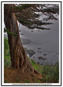
This photograph was taken on the Rim Trail, about a half mile from where I was camped.
Wild Goose Island, Glacier National Park, Montana USA
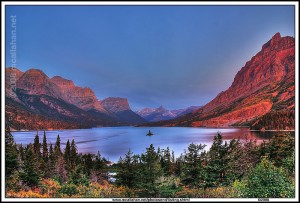
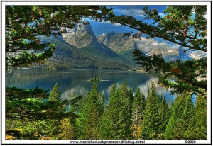
Pound for pound, I think the greatest scenery in all the National Parks (that I’ve been to anyway) is in Glacier National Park in Montana. Its hard to say that anything exceeds Denali National Park in Alaska. But if you don’t get knocked out by driving “Going to the Sun Road”, then I don’t know what WILL do it for you.
The next two photographs are of “Wild Goose Island” and Saint Mary Lake, on the eastern side of the USA portion of the park. The first one is taken from the most well known of the viewpoints for the island, right at sunrise.
The second photo is taken from a spot that I found, which involved a little bit of hiking around. I used the tree limbs to ‘frame’ the scene.
The island and the lake are the same. But notice how the changing of light conditions, and a different viewing perspective, can dramatically alter the photograph
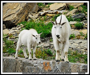
I just had to throw these guys in here too. Mountain goats. Big ones. Way too friendly.
These two goats demonstrated no fear of people. Or cars. One of them spent a good 45 minutes lapping up cooler drainage water, right off the parking lot asphalt. Can’t beat that human food taste. Then he caused a minor crisis because he wanted to do the same thing with some antifreeze boil off from another vehicle. But the rangers were right on that, keeping the goat away and washing the antifreeze down a handy storm drain.
Colorful Phlox Crop Rows – Washington State USA
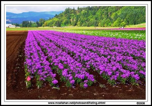
After leaving Mount Saint Helens National Monument, I drove north and then east in Washington State. I was headed for Mount Ranier National Park. Around the area of the town of Morton, Washington, I drove right by one of the most colorful roadside scenes I have ever found. I had to reverse course and go right back to photograph it, of course.
Row upon row of lavender, pink, red, and white color on a bright deep brown soil. Mountains and green trees in the background.
There were workers in the field, and it was obvious that they were very proud of their crop. Smiling, answering my questions, asking me if there was anything I wanted done to help me photograph – it was amazing! I am more accustomed to having to beg permission to shoot scenery and features along the road. This new attitude was totally unexpected. And, on top of all that, there was that pride written on their faces. They knew they had the most beautiful landscape for miles around, and they had created it themselves. My hat is off to them.
When I asked the name of the crop, they told me it was Phlox. I have googled till I am blue in the face trying to learn more about it. Like, is that even how it is spelled? If anyone can fill me in on some detail about Phlox, please don’t hesitate to enlighten me.
I hope you enjoyed the photograph. At least as much as I enjoyed being there to shoot it!

