Wild Goose Island, Glacier National Park, Montana USA

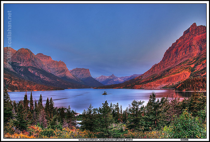
Pound for pound, I think the greatest scenery in all the National Parks (that I’ve been to anyway) is in Glacier National Park in Montana. Its hard to say that anything exceeds Denali National Park in Alaska. But if you don’t get knocked out by driving “Going to the Sun Road”, then I don’t know what WILL do it for you.

The next two photographs are of “Wild Goose Island” and Saint Mary Lake, on the eastern side of the USA portion of the park. The first one is taken from the most well known of the viewpoints for the island, right at sunrise.

wild_goose_island

The second photo is taken from a spot that I found, which involved a little bit of hiking around. I used the tree limbs to ‘frame’ the scene.

wild_goose_island_framed

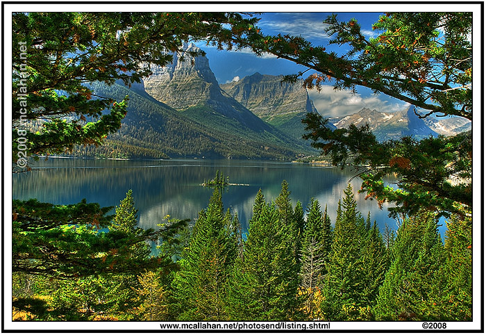
The island and the lake are the same. But notice how the changing of light conditions, and a different viewing perspective, can dramatically alter the photograph

I just had to throw these guys in here too. Mountain goats. Big ones. Way too friendly.

glacier_np_2goats

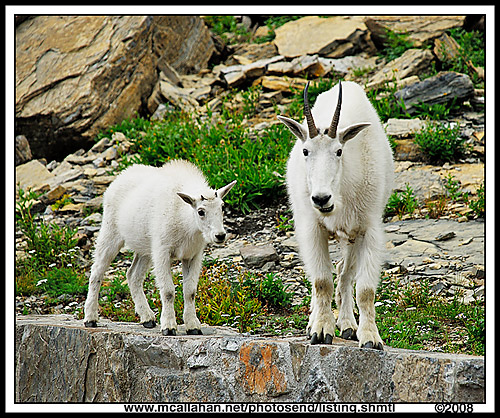
These two goats demonstrated no fear of people. Or cars. One of them spent a good 45 minutes lapping up cooler drainage water, right off the parking lot asphalt. Can’t beat that human food taste. Then he caused a minor crisis because he wanted to do the same thing with some antifreeze boil off from another vehicle. But the rangers were right on that, keeping the goat away and washing the antifreeze down a handy storm drain.

Colorful Phlox Crop Rows – Washington State USA

wa_phlox

After leaving Mount Saint Helens National Monument, I drove north and then east in Washington State. I was headed for Mount Ranier National Park. Around the area of the town of Morton, Washington, I drove right by one of the most colorful roadside scenes I have ever found. I had to reverse course and go right back to photograph it, of course.

Row upon row of lavender, pink, red, and white color on a bright deep brown soil. Mountains and green trees in the background.

There were workers in the field, and it was obvious that they were very proud of their crop. Smiling, answering my questions, asking me if there was anything I wanted done to help me photograph – it was amazing! I am more accustomed to having to beg permission to shoot scenery and features along the road. This new attitude was totally unexpected. And, on top of all that, there was that pride written on their faces. They knew they had the most beautiful landscape for miles around, and they had created it themselves. My hat is off to them.

When I asked the name of the crop, they told me it was Phlox. I have googled till I am blue in the face trying to learn more about it. Like, is that even how it is spelled? If anyone can fill me in on some detail about Phlox, please don’t hesitate to enlighten me.

I hope you enjoyed the photograph. At least as much as I enjoyed being there to shoot it!

Great Egret – Sebastian Inlet, Florida USA

great_egret

The Great Egret (Casmerodius albus) is distinguished from the Snowy Egret by its greater size (wingspan can be over 50 inches), and its yellow bill. While Great Egrets spend the winter from South Carolina southward, they can be found as far north as Massachusetts in the summer. Their nests, made up of reeds and sticks, are often high up in trees and may harbor as many as five or six eggs. In the breeding season, both males and females exhibit long back plumes that were once valued in the feather trade.

Egrets are excellent fishermen who stand motionless in the water waiting for fish, although snakes, frogs, or some insects may be added to their diet.

This Great Egret’s photograph was taken in mid February 2008 at Sebastian Inlet, Florida, USA.

For more information about Sebastian Inlet State Park in Florida, please visit:   Sebastian Inlet State Park 

Mount St. Helen’s Tortured Landscape Comes Back

mt_st_helens_torture

At 8:32AM PST, May 18 1980, on a Sunday morning, Mount St. Helens erupted in one of the most studied eruptions ever.

A 5.1 Richter scale earthquake caused the northern face of the mountain to collapse. It dropped over one half cubic mile of debris into the valley below, the largest avalanche ever recorded.

The avalanche released an enormous blast wave of hot gas and rock particle debris, with temperatures as high as 660 degrees and a speed of at least 300 miles per hour. The blast was phreatic, the result of super heated water trapped within the mountain. The actual blast began about 20 seconds after the avalanche began, and at the speed of something exploding, rapidly overtook the avalanche. It blew 6.6 billion tons of material with the force of 20,000 Hiroshima-class atomic bombs, 24 megatons of thermal energy. Its devastation reached out almost 16 miles from the volcano’s center

The blast killed campers 14 miles from the mountain. All told, the eruption killed 57 people.

Almost 230 square miles of forest was blown down.

A cloud of volcanic ash rose 15 miles into the air. It spread across the US in 3 days, and circled the earth in 15 days. There were 22,000 square miles of land with varying amounts of ash deposited on them.

In August of 2007 I visited Mount St. Helens National Volcanic Monument. I was happy to see the progress that Mother Nature is making in remaking the tortured landscape around the volcano.

But the scars are still visible on the land.

The 110,000 acre National Volcanic Monument was created in 1982 by President Ronald Reagan and Congress. It is jointly a research, recreational, and educational project. Much of the site is within a boundary line which only authorized personnel may cross. This is to minimize the effect of man on the area, that it may be left to respond to the disturbance naturally, and provide a study of the process. There is climbing allowed along a specified route to the crater rim, but entry into the crater is strictly prohibited.

Johnston Ridge Observatory Complex building has a number of educational exhibits, and even an IMAX movie presentation. There is also a monument to those who lost their lives in the eruption. The stories of what happened to the wildlife and plants in the blast zone were fascinating.

I was struck by the color in the landscape, as Mother Nature works to restore it to a more gentle state. The pronounced scarring on the land offered a stern counterpoint to this process, and a reminder that it will most likely all happen again at some time in the future.

For an interesting statistical summary of the 1980 Mount St. Helens eruption, check out this website: www.mtsthelens.com 

Tunnel in Mount Ranier National Park, WA USA

ranier_tunnel

Mount Ranier National Park in Washington state is another of our countries natural jewels. Established in 1899, it has the ‘feel’ of an old park. At over 200 thousand acres in size, and Mount Ranier’s peak of over 14 thousand feet, it makes for a large variety of stunning scenery.

Driving the southern section of the park, you will pass thru several tunnels bored thru solid rock. This photograph is taken from inside one of those tunnels, looking back outside to the east. (Note: Please be very careful if you decide to try and take a photograph like this. With running water and wind noise, it can be hard to hear traffic approaching you). This image was taken early in the morning, hoping to avoid traffic intrusion as much as possible.

Notice that you can see both the rock inside the tunnel, which is relatively dark compared to the outside light level, and the more brightly lit trees outside the tunnel entrance. In a traditional photograph, only one or the other of these two areas would be properly exposed and visible, and the other would either be burned out by bright light, or dropped out in dark shadow.

This photograph exhibits a wider range of light level visibility because it is an HDR processed image. HDR stands for High Dynamic Range. The image is a combination of multiple exposures, each one exposed for a different range of light level. The multiple exposures are then combined into a single HDR digital negative, and the resulting HDR image is digitally processed from that hybrid negative. The image has all the light levels adjusted such that they can be seen even on the limited range provided by your computer screen. This more closely simulates the way your eye naturally views the same scene.

I hope you enjoy the photograph, and I want to take this opportunity to wish all of you a very Happy Holiday Season!

Lassen Volcanic National Park, CA USA

lassen_lake_helen

Driving into Lassen Volcanic National Park in California, the first thing that struck me was the range of vivid, bright colors in the landscape all around me. From fresh greens, dark overhead blue, back-lighted purple colored Thrift ground flowers, light white clouds, and on and on. Its like driving into a new section of the land that is being lit by some special kind of light. Add the deep blue sky reflection off the water in lake Helen, and you have a window on paradise.

Eerie Twilight @ Ancient Bristlecone Forest, CA USA

bristlecone_eerie

The Ancient Bristlecone Pine Forest is located in the White Mountains of California. The Patriot Grove is the highest elevation grove in the park, at 11,323 feet.

When twilight and then nighttime come along, it can be a very eerie place. The dark blue skies of high elevation, 40 miles from civilization, no one around, and no lights in any direction as far as you can see, only the ancient Bristlecone Pines standing around you. If you watch overhead at night, meteors frequently fly soundlessly, and FAST, across the sky above you.

This shot was taken right at twilight, as the sun was about to go down behind the far mountains.

Guadalupe Mountains National Park, TX USA

I arrived back home from a 5 week, 7900 mile roadtrip, at the end of August. I am happy to say there is still plenty of unspoiled, beautiful scenery in our country. I was also awed by the vast array of natural resources our country has, from one end to the other.

In Texas, on my way out to California, I wanted to go to Big Bend National Park, down south on the Rio Grande River. But there were heavy storms down there at the time, and being in a tent in the rain is not exactly a pleasant experience (to me anyway). So I looked over my map and noticed Guadalupe Mountains National Park in the northwest corner of Texas. I had never been there before, nor even heard of it. I went on up, and found it to be a scenic location, with land I don’t normally equate with Texas.

Here is a photograph of Casa Grande Peak.

GuadalupeMtNatPark1